| at: |
Coopers Furnace Day Use Area |
Data from David Muse
 show on map
 animate
Trail users:


Elevation Profile
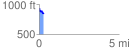
 0.291001 mi
 16.90 ft
 117.13 ft
 -100.23 ft
 7.62 %
GPX Downloads: Track Route
![]()
| at: |
Coopers Furnace Day Use Area |
show on map
animate
0.291001 mi
16.90 ft
117.13 ft
-100.23 ft
7.62 %