| at: |
Blue Ridge WMA |
Data from David Muse
 show on map
 animate


Trail users:

Elevation Profile
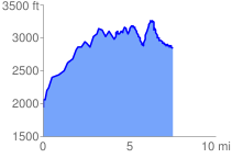
 7.546583 mi
 2577.52 ft
 1665.73 ft
 911.79 ft
 6.47 %
GPX Downloads: Track Route
![]()
| at: |
Blue Ridge WMA |
show on map
animate
7.546583 mi
2577.52 ft
1665.73 ft
911.79 ft
6.47 %