| at: |
Ocoee Whitewater Center |
Data from David Muse
 show on map
 animate
Trail users:


Elevation Profile
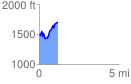
 1.159561 mi
 459.30 ft
 259.10 ft
 200.20 ft
 7.50 %
GPX Downloads: Track Route
![]()
| at: |
Ocoee Whitewater Center |
show on map
animate
1.159561 mi
459.30 ft
259.10 ft
200.20 ft
7.50 %