| at: |
Tribble Mill |
Data from Positive Flow
 show on map
 animate
Trail users:


Elevation Profile
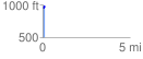
 0.129698 mi
 37.32 ft
 2.37 ft
 34.95 ft
 5.45 %
GPX Downloads: Track Route
![]()
| at: |
Tribble Mill |
show on map
animate
0.129698 mi
37.32 ft
2.37 ft
34.95 ft
5.45 %