| at: |
Blue Ridge WMA |
Data from David Muse
 show on map
 animate


Trail users:

Elevation Profile
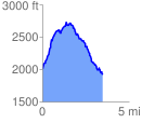
 3.579125 mi
 996.29 ft
 1114.96 ft
 -118.68 ft
 5.90 %
GPX Downloads: Track Route
Trailheads:
 Tooni Mountain
![]()
| at: |
Blue Ridge WMA |
show on map
animate
3.579125 mi
996.29 ft
1114.96 ft
-118.68 ft
5.90 %
Tooni Mountain