|
| at: |
Blue Ridge WMA |
Data from David Muse
 show on map
 animate
Trail users:


Elevation Profile
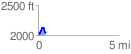
 0.499175 mi
 121.90 ft
 111.85 ft
 10.05 ft
 4.63 %
GPX Downloads: Track Route
![]()
|
| at: |
Blue Ridge WMA |
show on map
animate
0.499175 mi
121.90 ft
111.85 ft
10.05 ft
4.63 %