| at: |
Tsali Recreation Area |
Data from HikeWNC (HikeWNC.com)
 show on map
 animate
Trail users:


Elevation Profile
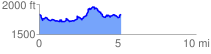
 5.268751 mi
 1162.31 ft
 1158.98 ft
 3.33 ft
 4.18 %
GPX Downloads: Track Route
Trailheads:
 Tsali
Tsali![]()
| at: |
Tsali Recreation Area |
show on map
animate
5.268751 mi
1162.31 ft
1158.98 ft
3.33 ft
4.18 %
Tsali