|
| at: |
South Oconee National Forest |
Data from David Muse
 show on map
 animate
Trail users:


Elevation Profile
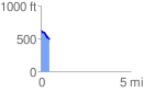
 0.501842 mi
 0.46 ft
 143.09 ft
 -142.62 ft
 5.40 %
GPX Downloads: Track Route
![]()
|
| at: |
South Oconee National Forest |
show on map
animate
0.501842 mi
0.46 ft
143.09 ft
-142.62 ft
5.40 %