|
| at: |
Iron Mountain/Sumac Creek |
Data from David Muse
 show on map
 animate
Trail users:


Elevation Profile
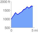
 4.653501 mi
 1154.92 ft
 377.54 ft
 777.38 ft
 4.70 %
GPX Downloads: Track Route
![]()
|
| at: |
Iron Mountain/Sumac Creek |
show on map
animate
4.653501 mi
1154.92 ft
377.54 ft
777.38 ft
4.70 %