|
| at: |
Iron Mountain/Sumac Creek |
Data from David Muse
 show on map
 animate
Trail users:


Elevation Profile
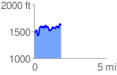
 1.878168 mi
 544.77 ft
 392.48 ft
 152.29 ft
 5.49 %
GPX Downloads: Track Route
![]()
|
| at: |
Iron Mountain/Sumac Creek |
show on map
animate
1.878168 mi
544.77 ft
392.48 ft
152.29 ft
5.49 %