|
| at: |
Chestatee WMA |
Data from David Muse
 show on map
 animate
Trail users:


Elevation Profile
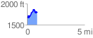
 0.866601 mi
 302.12 ft
 179.91 ft
 122.21 ft
 6.60 %
GPX Downloads: Track Route
![]()
|
| at: |
Chestatee WMA |
show on map
animate
0.866601 mi
302.12 ft
179.91 ft
122.21 ft
6.60 %