|
| at: |
South Oconee National Forest |
Data from David Muse
 show on map
 animate
Trail users:


Elevation Profile
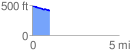
 1.013912 mi
 14.48 ft
 85.22 ft
 -70.73 ft
 1.59 %
GPX Downloads: Track Route
![]()
|
| at: |
South Oconee National Forest |
show on map
animate
1.013912 mi
14.48 ft
85.22 ft
-70.73 ft
1.59 %