|
| at: |
Iron Mountain/Sumac Creek |
Data from Josh Bailey
 show on map
 animate
Trail users:


Elevation Profile
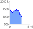
 2.950048 mi
 639.34 ft
 1172.68 ft
 -533.34 ft
 7.53 %
GPX Downloads: Track Route
![]()
|
| at: |
Iron Mountain/Sumac Creek |
show on map
animate
2.950048 mi
639.34 ft
1172.68 ft
-533.34 ft
7.53 %