| at: |
Iron Mountain/Sumac Creek |
Data from David Muse
 show on map
 animate
Trail users:


Elevation Profile
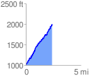
 2.448895 mi
 1093.65 ft
 103.50 ft
 990.14 ft
 8.46 %
GPX Downloads: Track Route
![]()
| at: |
Iron Mountain/Sumac Creek |
show on map
animate
2.448895 mi
1093.65 ft
103.50 ft
990.14 ft
8.46 %