| at: |
Coleman River Scenic Area |
Data from David Muse
 show on map
 animate
Trail users:


Elevation Profile
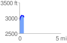
 0.540847 mi
 172.94 ft
 53.53 ft
 119.41 ft
 6.06 %
GPX Downloads: Track Route
![]()
| at: |
Coleman River Scenic Area |
show on map
animate
0.540847 mi
172.94 ft
53.53 ft
119.41 ft
6.06 %