|
| at: |
Cane Creek/Two Run |
Data from David Muse
 show on map
 animate
Trail users:


Elevation Profile
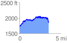
 3.594008 mi
 924.28 ft
 868.53 ft
 55.74 ft
 4.87 %
GPX Downloads: Track Route
![]()
|
| at: |
Cane Creek/Two Run |
show on map
animate
3.594008 mi
924.28 ft
868.53 ft
55.74 ft
4.87 %