|
| at: |
Johns Mountain WMA |
Data from David Muse
 show on map
 animate
Trail users:


Elevation Profile
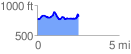
 2.563088 mi
 371.29 ft
 333.72 ft
 37.57 ft
 2.74 %
GPX Downloads: Track Route
![]()
|
| at: |
Johns Mountain WMA |
show on map
animate
2.563088 mi
371.29 ft
333.72 ft
37.57 ft
2.74 %