|
| at: |
South Oconee National Forest |
Data from David Muse
 show on map
 animate
Trail users:


Elevation Profile
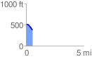
 0.564109 mi
 7.75 ft
 126.98 ft
 -119.23 ft
 4.26 %
GPX Downloads: Track Route
![]()
|
| at: |
South Oconee National Forest |
show on map
animate
0.564109 mi
7.75 ft
126.98 ft
-119.23 ft
4.26 %