|
| at: |
Iron Mountain/Sumac Creek |
Data from David Muse
 show on map
 animate
Trail users:


Elevation Profile
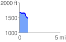
 1.098289 mi
 96.09 ft
 253.71 ft
 -157.62 ft
 4.38 %
GPX Downloads: Track Route
![]()
|
| at: |
Iron Mountain/Sumac Creek |
show on map
animate
1.098289 mi
96.09 ft
253.71 ft
-157.62 ft
4.38 %