|
| at: |
North Oconee National Forest |
Data from David Muse
 show on map
 animate
Trail users:


Elevation Profile
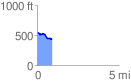
 0.907754 mi
 16.48 ft
 120.02 ft
 -103.54 ft
 2.50 %
GPX Downloads: Track Route
![]()
|
| at: |
North Oconee National Forest |
show on map
animate
0.907754 mi
16.48 ft
120.02 ft
-103.54 ft
2.50 %