|
| at: |
South Oconee National Forest |
Data from David Muse
 show on map
 animate
Trail users:


Elevation Profile
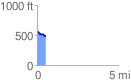
 0.511951 mi
 0.04 ft
 79.73 ft
 -79.69 ft
 2.95 %
GPX Downloads: Track Route
![]()
|
| at: |
South Oconee National Forest |
show on map
animate
0.511951 mi
0.04 ft
79.73 ft
-79.69 ft
2.95 %