|
| at: |
Lake Conasauga Recreation Area |
Data from David Muse
 show on map
 animate
Trail users:


Elevation Profile
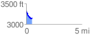
 0.546024 mi
 31.53 ft
 202.57 ft
 -171.05 ft
 7.03 %
GPX Downloads: Track Route
![]()
|
| at: |
Lake Conasauga Recreation Area |
show on map
animate
0.546024 mi
31.53 ft
202.57 ft
-171.05 ft
7.03 %