|
| at: |
Wolf Creek Area |
Data from David Muse
 show on map
 animate
Trail users:


Elevation Profile
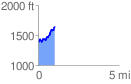
 1.035511 mi
 360.97 ft
 99.49 ft
 261.48 ft
 6.60 %
GPX Downloads: Track Route
![]()
|
| at: |
Wolf Creek Area |
show on map
animate
1.035511 mi
360.97 ft
99.49 ft
261.48 ft
6.60 %