|
| at: |
Brawley Mountain |
Data from David Muse
 show on map
 animate
Trail users:


Elevation Profile
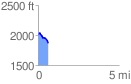
 0.633746 mi
 34.23 ft
 173.56 ft
 -139.33 ft
 5.19 %
GPX Downloads: Track Route
![]()
|
| at: |
Brawley Mountain |
show on map
animate
0.633746 mi
34.23 ft
173.56 ft
-139.33 ft
5.19 %