|
| at: |
South Oconee National Forest |
Data from David Muse
 show on map
 animate
Trail users:


Elevation Profile
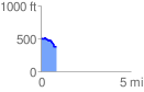
 0.878706 mi
 28.55 ft
 159.87 ft
 -131.32 ft
 3.45 %
GPX Downloads: Track Route
![]()
|
| at: |
South Oconee National Forest |
show on map
animate
0.878706 mi
28.55 ft
159.87 ft
-131.32 ft
3.45 %