|
| at: |
North Oconee National Forest |
Data from David Muse
 show on map
 animate
Trail users:


Elevation Profile
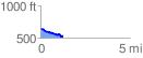
 1.265769 mi
 58.37 ft
 156.56 ft
 -98.19 ft
 2.34 %
GPX Downloads: Track Route
![]()
|
| at: |
North Oconee National Forest |
show on map
animate
1.265769 mi
58.37 ft
156.56 ft
-98.19 ft
2.34 %