|
| at: |
Johns Mountain WMA |
Data from David Muse
 show on map
 animate
Trail users:


Elevation Profile
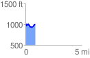
 0.861123 mi
 146.38 ft
 112.14 ft
 34.24 ft
 3.22 %
GPX Downloads: Track Route
![]()
|
| at: |
Johns Mountain WMA |
show on map
animate
0.861123 mi
146.38 ft
112.14 ft
34.24 ft
3.22 %