|
| at: |
Lake Chatuge Recreation Area |
Data from David Muse
 show on map
 animate
Trail users:


Elevation Profile
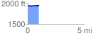
 0.982780 mi
 47.05 ft
 50.40 ft
 -3.36 ft
 0.97 %
GPX Downloads: Track Route
![]()
|
| at: |
Lake Chatuge Recreation Area |
show on map
animate
0.982780 mi
47.05 ft
50.40 ft
-3.36 ft
0.97 %