|
| at: |
Gaddistown/Canada Creek |
Data from David Muse
 show on map
 animate
Trail users:


Elevation Profile
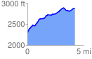
 4.256527 mi
 784.71 ft
 221.71 ft
 563.00 ft
 3.49 %
GPX Downloads: Track Route
![]()
|
| at: |
Gaddistown/Canada Creek |
show on map
animate
4.256527 mi
784.71 ft
221.71 ft
563.00 ft
3.49 %