|
| at: |
Johns Mountain WMA |
Data from David Muse
 show on map
 animate
Trail users:


Elevation Profile
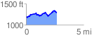
 2.656454 mi
 401.28 ft
 296.65 ft
 104.64 ft
 2.86 %
GPX Downloads: Track Route
![]()
|
| at: |
Johns Mountain WMA |
show on map
animate
2.656454 mi
401.28 ft
296.65 ft
104.64 ft
2.86 %