|
| at: |
Johns Mountain WMA |
Data from David Muse
 show on map
 animate
Trail users:


Elevation Profile
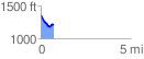
 0.725216 mi
 43.81 ft
 196.16 ft
 -152.35 ft
 5.12 %
GPX Downloads: Track Route
![]()
|
| at: |
Johns Mountain WMA |
show on map
animate
0.725216 mi
43.81 ft
196.16 ft
-152.35 ft
5.12 %