|
| at: |
Johns Mountain WMA |
Data from David Muse
 show on map
 animate
Trail users:


Elevation Profile
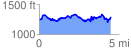
 4.517997 mi
 903.68 ft
 870.57 ft
 33.11 ft
 3.79 %
GPX Downloads: Track Route
![]()
|
| at: |
Johns Mountain WMA |
show on map
animate
4.517997 mi
903.68 ft
870.57 ft
33.11 ft
3.79 %