|
| at: |
North Oconee National Forest |
Data from David Muse
 show on map
 animate
Trail users:


Elevation Profile
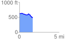
 1.692063 mi
 51.76 ft
 189.59 ft
 -137.83 ft
 2.12 %
GPX Downloads: Track Route
![]()
|
| at: |
North Oconee National Forest |
show on map
animate
1.692063 mi
51.76 ft
189.59 ft
-137.83 ft
2.12 %