|
| at: |
Stonewall Falls Area |
Data from David Muse
 show on map
 animate
Trail users:


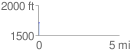
Elevation Profile
 0.060161 mi
 0.68 ft
 2.24 ft
 -1.57 ft
 0.71 %
GPX Downloads: Track Route
![]()
|
| at: |
Stonewall Falls Area |
show on map
animate
0.060161 mi
0.68 ft
2.24 ft
-1.57 ft
0.71 %