|
| at: |
Lake Russell WMA |
Data from David Muse
 show on map
 animate
Trail users:


Elevation Profile
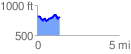
 1.365141 mi
 222.81 ft
 246.49 ft
 -23.68 ft
 3.42 %
GPX Downloads: Track Route
![]()
|
| at: |
Lake Russell WMA |
show on map
animate
1.365141 mi
222.81 ft
246.49 ft
-23.68 ft
3.42 %