|
| at: |
Johns Mountain WMA |
Data from David Muse
 show on map
 animate
Trail users:


Elevation Profile
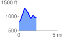
 2.267334 mi
 604.90 ft
 492.76 ft
 112.14 ft
 5.05 %
GPX Downloads: Track Route
![]()
|
| at: |
Johns Mountain WMA |
show on map
animate
2.267334 mi
604.90 ft
492.76 ft
112.14 ft
5.05 %