|
| at: |
Iron Mountain/Sumac Creek |
Data from David Muse
 show on map
 animate
Trail users:


Elevation Profile
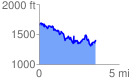
 3.565295 mi
 934.78 ft
 1191.18 ft
 -256.40 ft
 6.33 %
GPX Downloads: Track Route
![]()
|
| at: |
Iron Mountain/Sumac Creek |
show on map
animate
3.565295 mi
934.78 ft
1191.18 ft
-256.40 ft
6.33 %