| at: |
Data from $(FIRST_NAME) $(LAST_NAME)
 show on map
 animate
$(CONVERTED_ARTICLE)
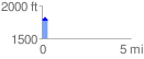
Trail users:Elevation Profile
 $(TOTAL_DISTANCE) mi
 $(CONVERTED_TOTAL_CLIMBING) ft
 $(CONVERTED_TOTAL_DESCENDING) ft
 $(NET_CLIMBING) ft
 $(AVG_PCT_GRADE) %
GPX Downloads: Track Route