|
| at: |
North Oconee National Forest |
Data from David Muse
 show on map
 animate
Trail users:


Elevation Profile
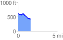
 1.630255 mi
 59.39 ft
 246.54 ft
 -187.14 ft
 2.86 %
GPX Downloads: Track Route
![]()
|
| at: |
North Oconee National Forest |
show on map
animate
1.630255 mi
59.39 ft
246.54 ft
-187.14 ft
2.86 %