|
| at: |
South Oconee National Forest |
Data from David Muse
 show on map
 animate
Trail users:


Elevation Profile
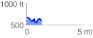
 1.323208 mi
 170.53 ft
 258.30 ft
 -87.77 ft
 3.70 %
GPX Downloads: Track Route
![]()
|
| at: |
South Oconee National Forest |
show on map
animate
1.323208 mi
170.53 ft
258.30 ft
-87.77 ft
3.70 %