|
| at: |
Morganton Point Recreation Area |
Data from David Muse
 show on map
 animate
Trail users:


Elevation Profile
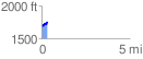
 0.324700 mi
 76.28 ft
 17.76 ft
 58.53 ft
 4.45 %
GPX Downloads: Track Route
![]()
|
| at: |
Morganton Point Recreation Area |
show on map
animate
0.324700 mi
76.28 ft
17.76 ft
58.53 ft
4.45 %