|
| at: |
Coleman River Scenic Area |
Data from David Muse
 show on map
 animate
Trail users:


Elevation Profile
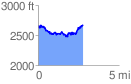
 2.800717 mi
 717.28 ft
 694.94 ft
 22.34 ft
 4.85 %
GPX Downloads: Track Route
![]()
|
| at: |
Coleman River Scenic Area |
show on map
animate
2.800717 mi
717.28 ft
694.94 ft
22.34 ft
4.85 %