|
| at: |
Blue Ridge WMA |
Data from David Muse
 show on map
 animate
Trail users:


Elevation Profile
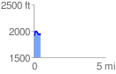
 0.487316 mi
 111.26 ft
 69.00 ft
 42.27 ft
 4.32 %
GPX Downloads: Track Route
![]()
|
| at: |
Blue Ridge WMA |
show on map
animate
0.487316 mi
111.26 ft
69.00 ft
42.27 ft
4.32 %