|
| at: |
Johns Mountain WMA |
Data from David Muse
 show on map
 animate
Trail users:


Elevation Profile
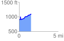
 1.535803 mi
 318.60 ft
 119.63 ft
 198.97 ft
 3.93 %
GPX Downloads: Track Route
![]()
|
| at: |
Johns Mountain WMA |
show on map
animate
1.535803 mi
318.60 ft
119.63 ft
198.97 ft
3.93 %