|
| at: |
Oakey Mountain |
Data from David Muse
 show on map
 animate
Trail users:


Elevation Profile
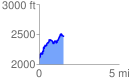
 1.536556 mi
 519.29 ft
 173.16 ft
 346.13 ft
 6.40 %
GPX Downloads: Track Route
![]()
|
| at: |
Oakey Mountain |
show on map
animate
1.536556 mi
519.29 ft
173.16 ft
346.13 ft
6.40 %