|
| at: |
South Oconee National Forest |
Data from David Muse
 show on map
 animate
Trail users:


Elevation Profile
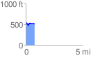
 0.763911 mi
 51.34 ft
 75.82 ft
 -24.48 ft
 1.88 %
GPX Downloads: Track Route
![]()
|
| at: |
South Oconee National Forest |
show on map
animate
0.763911 mi
51.34 ft
75.82 ft
-24.48 ft
1.88 %