|
| at: |
South Oconee National Forest |
Data from David Muse
 show on map
 animate
Trail users:


Elevation Profile
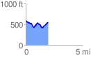
 1.967226 mi
 241.00 ft
 281.13 ft
 -40.13 ft
 2.71 %
GPX Downloads: Track Route
![]()
|
| at: |
South Oconee National Forest |
show on map
animate
1.967226 mi
241.00 ft
281.13 ft
-40.13 ft
2.71 %