|
| at: |
Johns Mountain WMA |
Data from David Muse
 show on map
 animate
Trail users:


Elevation Profile
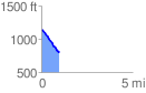
 0.999485 mi
 3.46 ft
 343.08 ft
 -339.61 ft
 6.50 %
GPX Downloads: Track Route
![]()
|
| at: |
Johns Mountain WMA |
show on map
animate
0.999485 mi
3.46 ft
343.08 ft
-339.61 ft
6.50 %