|
| at: |
South Oconee National Forest |
Data from David Muse
 show on map
 animate
Trail users:


Elevation Profile
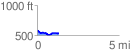
 1.325244 mi
 70.34 ft
 110.54 ft
 -40.20 ft
 1.58 %
GPX Downloads: Track Route
![]()
|
| at: |
South Oconee National Forest |
show on map
animate
1.325244 mi
70.34 ft
110.54 ft
-40.20 ft
1.58 %