|
| at: |
Lake Russell WMA |
Data from USFS GIS
 show on map
 animate
Trail users:


Elevation Profile
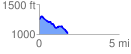
 1.786939 mi
 115.12 ft
 352.11 ft
 -236.99 ft
 3.73 %
GPX Downloads: Track Route
![]()
|
| at: |
Lake Russell WMA |
show on map
animate
1.786939 mi
115.12 ft
352.11 ft
-236.99 ft
3.73 %